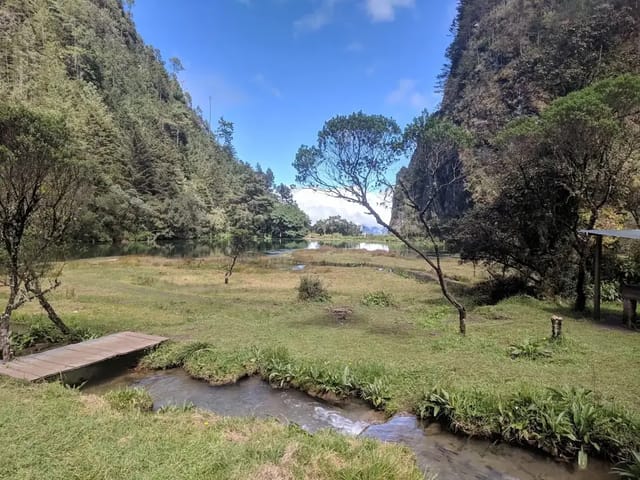
Laguna Brava, also called Yolnabaj, is a lake in aldea El Aguacate, in the municipality of Nentón, Huehuetenango, at 1,142 metres above sea level (AGN, April 2021). A guide quoted by Emisoras Unidas in January 2021 described the way in as Nentón, the road to La Trinidad and El Aguacate, a 4x4 vehicle and then a 1.5 km walk to the shore, where you can camp. AGN puts the Nentón attractions about 4 to 5 hours from the town of Huehuetenango. At Easter 2021, after rain from a cold front trapped campers, about 500 people were evacuated from the lake in police vehicles.
INGUAT’s 2026 Huehuetenango guide calls Laguna Brava one of the region’s major natural attractions, in a remote area, known for its clear water and forest setting, with part of it explorable by motorboat or local canoe. It also warns that it is a long way from the main town. This page sets out the access routes, facilities and risks as each source describes them, with dates, as of 1 November 2026.
Quick summary
| Item | Value |
|---|---|
| Location | Aldea El Aguacate, Nentón, Huehuetenango (AGN, 2021) |
| Other name | Yolnabaj (AGN, 2021; Prensa Libre, 2016) |
| Elevation | 1,142 m (AGN, 2021; Prensa Libre, 2016) |
| From Guatemala City | 405 km (Prensa Libre, 2016) |
| From Huehuetenango town | About 4 to 5 hours (AGN, 16 September 2022) |
| Last stretch | 4x4 from El Aguacate, then a 1.5 km walk (Emisoras Unidas, 2021) |
| On the water | Motorboat or local canoe (INGUAT, 2026); log rafts for hire (Prensa Libre, 2016) |
| Facilities | Shoreline camping, a shop with basic goods, a cabin, toilets (Emisoras Unidas, 2021) |
| Entry fee | Not stated by the sources on this page |
| Climate | Warm in Nentón (Prensa Libre, 2016) |
Where it is and what the name means
AGN’s April 2021 report locates the lake in aldea El Aguacate, Nentón, and gives its elevation as 1,142 metres. Prensa Libre’s March 2016 feature gives the same elevation and puts the lake 405 km from Guatemala City, north of Huehuetenango. It calls Laguna Brava the second-largest lake in the country’s northwest after Lake Atitlán, and says it is named for the sound the wind makes over the water in the late afternoon, which villagers say makes it roar.
The sources give two meanings for the original name:
| Source | Meaning of Yolnabaj |
|---|---|
| AGN, 2 April 2021 | From Ob, meaning bravo (wild), and Nhajab’, meaning lake |
| Prensa Libre, 30 March 2016 | In Chuj, abajo en el agua (down in the water) |
Getting there: two routes, two dates
| Source and date | Route | Vehicle | Walk |
|---|---|---|---|
| Emisoras Unidas, 2 January 2021 (guide Marlon Vásquez, Caza Aventuras Guatemala) | Through Nentón, then the road to La Trinidad and aldea El Aguacate | Switch to a 4x4 at El Aguacate | 1.5 km to the shore |
| Prensa Libre, 30 March 2016 | A dirt trail that leaves the main road at aldea Yalambojoch; the walk can also start from the Franja Transversal del Norte | Not stated | Three hours; a guide is described as very important |
The 2016 feature also says that before entering the forest you can visit communities such as Chaculá, made up of people who fled their land during the internal war, which offers ecotourism services including lodging. AGN (September 2022) groups Laguna Brava with the Candelaria cenotes, the Cimarrón and Río Azul as attractions in and around Nentón, about 4 to 5 hours from the town of Huehuetenango. INGUAT’s guide adds that the distances in the department are significant and that some places need a high-clearance vehicle, a local guide or a full day.
To reach Huehuetenango first, see Guatemala City to Huehuetenango. For self-drivers, see our driving in Guatemala guide.
On the lake
INGUAT says part of the area can be explored by motorboat or local canoe. The 2016 Prensa Libre feature described rafts made of logs rented at modest prices, and water that turns sky-blue and turquoise further out because of its depth. Emisoras Unidas (2021) says that on clear nights there is a show of stars over the camp. None of the sources gives a price for boats, rafts or camping. If you go on the water, read our water safety guide first.
Camping and facilities
According to Emisoras Unidas (January 2021), you can camp on the shore, and there is a shop with basic products, a cabin for those who do not want to camp, and toilets. The guide it quotes, Marlon Vásquez of Caza Aventuras Guatemala, recommended travelling in a group and taking your rubbish home with you.
The Easter 2021 evacuation
AGN reported on 2 April 2021 (Good Friday) that dozens of tourists who had been camping at the lake since Holy Thursday, when the rain began, had been trapped and were evacuated. The Army, CONRED, firefighters and the National Civil Police took part; the police said about 500 people were evacuated in police vehicles, and the site was closed to visitors that Good Friday. INSIVUMEH attributed the rain to a cold front. Check the weather forecast before a camping trip.
When to plan it
INGUAT’s guide suggests the city, Zaculeu and Chiantla for the first days and Laguna Brava for a third day or a longer trip once you have been in the department for three or four days. The Candelaria cenotes are in the same municipality; see Cenotes de Candelaria.
Nearby
- Things to do in Huehuetenango: Zaculeu, Chiantla and the Cuchumatanes.
- Cenotes de Candelaria, Nentón: two open-air cenotes in the same municipality.
- Laguna Magdalena, Chiantla: a high Cuchumatanes lake with an entry fee and cabins.
Sources
- AGN, Evacuan a turistas de la laguna Brava debido a la lluvia (2 April 2021): https://agn.gt/evacuan-a-turistas-de-la-laguna-brava-debido-a-la-lluvia/ (read 1 November 2026)
- AGN, Huehuetenango, destino para este fin de semana largo (16 September 2022): https://agn.gt/huehuetenango-para-este-fin-de-semana-largo/ (read 1 November 2026)
- INGUAT, Huehuetenango: What to see, what to do and how to get there (17 September 2026): https://visitguatemala.gt/en/blog/what-see-do-huehuetenango/ (read 1 November 2026)
- Emisoras Unidas, Tips para disfrutar de un campamento a la orilla de una laguna en Huehuetenango (2 January 2021): https://emisorasunidas.com/2021/01/02/tips-para-disfrutar-de-un-campamento-a-la-orilla-de-una-laguna-en-huehuetenango/ (read 1 November 2026)
- Prensa Libre, Laguna Brava, un espejo celestial (30 March 2016): https://www.prensalibre.com/hemeroteca/laguna-brava-un-espejo-celestial/ (read 1 November 2026)
Affiliate links — if you book, we earn a commission at no extra cost to you.
Before you pay, check each plan's medical-evacuation limit and its rules for hiking and adventure activities. Three options, as each company describes them on its own site:
- Genki Traveler: a monthly subscription for up to 12 months that covers up to €1,000,000 for unexpected medical care while traveling abroad, at public and private doctors and hospitals.
- SafetyWing Nomad Insurance: the Essential plan is travel medical insurance paid every 4 weeks; the Complete plan is full health insurance with extra travel protections.
- Faye: single-trip plans sold to residents of U.S. states (not U.S. territories); its FAQ lists emergency medical cover of up to $250K and emergency medical evacuation of up to $500K, and adventure and extreme activities need a paid add-on for medical cover.
Limits, prices and the altitude rules side by side: travel insurance for Guatemala · insurance for volcano hikes
Affiliate links: we earn a commission if you buy, at no extra cost to you. Plan descriptions come from each insurer's own site, read September 22-25, 2026; Genki's limit is in euros, Faye's in U.S. dollars; this is not insurance advice. Disclosure
Frequently Asked Questions
Where is Laguna Brava in Guatemala?
In the municipality of Nentón, Huehuetenango. AGN (2 April 2021) places it in aldea El Aguacate, at 1,142 metres above sea level. Prensa Libre (2016) puts it 405 km from Guatemala City, north of Huehuetenango.
How do you get to Laguna Brava?
A guide quoted by Emisoras Unidas (2 January 2021) described the route as Nentón, then the road to La Trinidad and aldea El Aguacate, where you switch to a 4x4 vehicle, then a walk of 1.5 km to the shore. Prensa Libre (2016) described a dirt trail leaving the main road at aldea Yalambojoch and a three-hour walk, and stressed the importance of a guide.
How long does it take to reach Laguna Brava from Huehuetenango?
AGN (16 September 2022) puts Laguna Brava and the other Nentón attractions about 4 to 5 hours from the town of Huehuetenango. INGUAT’s 2026 guide says it is a long way from the main town and suggests it for travellers with three or four days in the department.
Can you camp at Laguna Brava?
Yes, according to Emisoras Unidas (January 2021), which says you can camp on the shore and that there is a shop with basic goods, a cabin and toilets. In April 2021 campers had to be evacuated after heavy rain, so check the forecast.
What does Yolnabaj mean?
The sources disagree. AGN (2021) says Yolnabaj comes from Ob, meaning bravo (wild), and Nhajab’, meaning lake. Prensa Libre (2016) says that in Chuj it means abajo en el agua (down in the water).
Is there an entrance fee at Laguna Brava?
None of the official or press sources on this page states an entrance fee. Carry cash and ask in El Aguacate.