![Hiking Guatemala Volcanoes: 7 Trails Ranked [2026]](/images/photos/fuega-and-acatenango-sunset.jpg)
Guatemala sits on the Pacific Ring of Fire with 37 volcanoes, 3 of them active. Growing up here, volcanoes were just the backdrop to daily life. I did not fully appreciate how extraordinary they are until I started hiking them and realized you can stand on a 4,000-meter summit, watch another volcano erupt across the valley, and camp above the clouds – all for less than $50. Volcano hikes are one of the many free and affordable things to do in Guatemala.
This guide covers the 7 best volcanic hikes in the country, from beginner-friendly Pacaya to the highest point in Central America at Tajumulco. Every cost, elevation, and trail detail is based on current 2026 information.
TL;DR: Guatemala has 37 volcanoes and 7 hikeable ones, from beginner-friendly Pacaya (Q100/$13, 2 hours) to Tajumulco at 4,220m – the highest point in Central America. The iconic Acatenango overnight costs $30-60 with front-row views of Fuego erupting. Best season: November through April.
Volcano Comparison: Quick Reference
| Volcano | Elevation | Difficulty (1-5) | Duration | Cost (GTQ) | Cost (USD) | Best Season | Guide Required? |
|---|---|---|---|---|---|---|---|
| Acatenango | 3,976m | 4/5 | 2 days (overnight) | Q200-400 | $26-52 | Nov-Apr | Yes |
| Pacaya | 2,552m | 2/5 | 2-3 hrs round trip | Q100 | $13 | Year-round | Yes (included) |
| Tajumulco | 4,220m | 4/5 | 2 days | Q50 | $6.50 | Nov-Mar | Recommended |
| Agua | 3,760m | 3/5 | 6-8 hrs round trip | Q50 | $6.50 | Nov-Apr | Recommended |
| Santa Maria | 3,772m | 4/5 | 5-7 hrs round trip | Q50 | $6.50 | Nov-Mar | Recommended |
| Ipala | 1,650m | 1/5 | 1.5 hrs round trip | Q20 | $2.60 | Year-round | No |
| Fuego | 3,763m | – | NOT HIKEABLE | – | – | – | – |
Exchange rate used: Q7.7 = $1 USD
Prices verified February 2026. See our exchange rates page for today’s USD/GTQ rate.
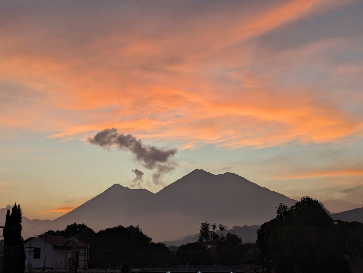
Acatenango: The Iconic Overnight Hike
Acatenango is Guatemala’s most famous hike, and for good reason. You camp at 3,800 meters and watch Volcan de Fuego erupt across the valley throughout the night. The eruptions happen every 15-30 minutes, sending glowing lava and ash plumes into the sky. It is genuinely one of the most spectacular things you will ever see.
The Trail
The standard route starts from La Soledad, a small community above the town of Alotenango. The trailhead sits at about 2,600 meters. From there it is roughly 7 kilometers and 1,400 meters of elevation gain to the main campsite at 3,800 meters. Most hikers take 4-6 hours going up.
The first section climbs through farmland and pine forest. Around 3,200 meters the vegetation shifts to cloud forest, and above 3,500 meters you are in sub-alpine scrub with increasingly exposed terrain. The final push to camp is steep and loose volcanic soil – two steps forward, one step back.
What It Costs
| Item | Tour (from Antigua) | Independent |
|---|---|---|
| Transport to trailhead | Included | Q50 (chicken bus) |
| Park entrance + guide | Included | Q200-400 |
| Tent + sleeping bag | Included | Bring your own |
| Meals (dinner + breakfast) | Included | Bring your own |
| Total | Q230-460 ($30-60) | Q250-450 ($32-58) |
Most people book a tour from Antigua. The cheapest reliable operators charge around Q230-300 per person and include transport, guide, tent, sleeping bag, dinner, and breakfast. Premium operators charge Q400-600 for smaller groups and better gear.
Tips From Experience
- Altitude is real. If you just landed in Guatemala, give yourself at least 2-3 days to acclimatize in Antigua (1,530m) before attempting Acatenango. Check our safety guide for more health tips.
- It gets brutally cold. Temperatures drop to -5C at the summit camp. Bring thermal layers, a beanie, gloves, and a good sleeping bag. Tour-provided sleeping bags are often thin.
- Start the summit push at 4 AM to catch sunrise from the peak at 3,976m.
- The descent destroys your knees. Bring trekking poles or at least a walking stick.
Explore the Sacatepequez department on our interactive map to see elevation data and nearby attractions.
Pacaya: The Perfect Beginner Volcano
If Acatenango is the main course, Pacaya is the appetizer. It is the most accessible volcano in Guatemala, just 45 minutes from Antigua and 90 minutes from Guatemala City. The hike is short, the trail is good, and you can roast marshmallows on active volcanic vents at the top.
The Trail
The standard route from San Francisco de Sales takes about 1-1.5 hours to reach the volcanic plateau. The first half is a moderate incline through pine forest. The second half crosses old lava flows from 2010 and 2014 eruptions – surreal black landscapes that feel like another planet. At the top, you will find areas where the ground is hot enough to melt the soles of your shoes if you stand still.
What It Costs
| Item | Cost |
|---|---|
| Park entrance (includes guide) | Q100 ($13) for foreigners |
| National rate | Q25 ($3.25) with DPI |
| Marshmallow kit | Q25 ($3.25) from vendors |
| Horseback up (optional) | Q100 ($13) |
| Tour from Antigua (transport + entry) | Q200-300 ($26-39) |
Tips
- The afternoon hike (2-3 PM departure) is better than morning – you get sunset views and can see the glowing lava vents in darkness.
- Vendors at the trailhead sell walking sticks (Q10) and marshmallow kits (Q25). Buy them – you will want both.
- Pacaya is active. Check INSIVUMEH before going. Eruptions occasionally close the trail.
Tajumulco: Highest Point in Central America
At 4,220 meters, Volcan Tajumulco is the highest point in Central America. It is located in the department of San Marcos, near the Mexican border. The summit is achievable as either a very long day hike or a more comfortable overnight trip.
The Trail
The trail starts from the small town of Tuichanchiquib at about 3,000 meters. The standard route is roughly 7 kilometers to the summit with 1,200 meters of elevation gain. Most hikers camp at a flat area around 3,800 meters and summit in the early morning for sunrise.
The trail is well-defined but can be muddy in the rainy season. Above 3,800 meters, the terrain becomes rocky and exposed. On a clear morning, you can see the Pacific Ocean, the Mexican highlands, and a chain of Guatemalan volcanoes stretching east.
What It Costs
| Item | Cost |
|---|---|
| Entrance fee | Q50 ($6.50) |
| Guide (recommended) | Q200-300 ($26-39) |
| Camping fee | Free (wild camp) |
| Transport from Xela | Q30-50 by chicken bus |
Tips
- Acclimatize first. Spend at least 2-3 days in Quetzaltenango (Xela) at 2,330m before attempting Tajumulco.
- Bring everything for cold weather. It can drop below -10C at the summit. Wind chill makes it worse.
- Dry season only (Nov-Mar) for clear views. Rainy season means fog and zero visibility.
Volcan de Agua: Day Hike From Santa Maria de Jesus
Agua is the photogenic cone that dominates Antigua’s skyline. At 3,760 meters, it is a serious day hike but does not require an overnight.
The Trail
Start from Santa Maria de Jesus (accessible by chicken bus from Antigua, Q5). The trailhead is at about 2,060 meters. The summit is 1,700 meters above – steep and relentless. Most hikers take 4-5 hours up and 2-3 hours down.
The upper sections have antennas and some structures at the summit, which makes it less pristine than Acatenango. But on a clear day, the panoramic views of Acatenango, Fuego (erupting), and the Pacific lowlands are spectacular.
| Item | Cost |
|---|---|
| Entrance fee | Q50 ($6.50) |
| Guide (from Santa Maria) | Q150-200 ($19-26) |
| Chicken bus Antigua - Santa Maria | Q5 ($0.65) |
Important: Start by 5 AM at the latest. Clouds roll in by noon and afternoon rain is almost guaranteed in the rainy season.
Santa Maria & Santiaguito: Erupting Volcano Views From Xela
Santa Maria sits above Quetzaltenango at 3,772 meters. Its main attraction is the view of Santiaguito, a highly active lava dome on Santa Maria’s flank that erupts multiple times per day with visible ash columns.
The Trail
The standard route starts from Llano del Pinal above Xela. It is about 4.5 kilometers and 1,400 meters of elevation gain – steep, direct, and takes 3-4 hours up. The trail is well-used but eroded in places.
From the summit, you look directly down at Santiaguito erupting below you. Time your hike to arrive at the summit early morning (6-8 AM) when eruptions are most visible and clouds have not yet formed.
| Item | Cost |
|---|---|
| Entrance fee | Q50 ($6.50) |
| Guide (from Xela) | Q200-300 ($26-39) |
Safety note: Stay on marked trails. Do not attempt to descend toward Santiaguito. The active dome produces pyroclastic flows without warning.
Ipala: The Easiest Volcano With a Crater Lake
Ipala is the gentle outlier. At just 1,650 meters with a well-maintained trail, it takes about 45 minutes to reach the rim. The reward is a beautiful crater lake at the top where you can swim.
Located in the eastern department of Chiquimula, Ipala is far from the typical tourist circuit but makes an excellent day trip if you are heading to or from Copan Ruinas in Honduras or exploring eastern Guatemala.
| Item | Cost |
|---|---|
| Entrance fee | Q20 ($2.60) |
| Guide | Not required |
| Transport from Chiquimula | Q15-20 by microbus |
Best for: Families, people with limited fitness, anyone wanting a relaxed hike with a unique reward. Explore eastern Guatemala on the map.
Volcan de Fuego: Why You Cannot Hike It
Fuego is one of the most active volcanoes in the Americas. It erupts multiple times per day – small explosions, lava flows, and ash plumes. The devastating eruption of June 3, 2018 killed over 190 people and buried the community of San Miguel Los Lotes under pyroclastic flows.
Fuego is strictly off-limits. There is no legal or safe way to hike it. Do not let anyone convince you otherwise.
The best way to experience Fuego is from the Acatenango overnight hike, which puts you at eye level with the eruptions from a safe distance across the valley. The nighttime eruptions, with glowing lava arcing through the darkness, are the main reason Acatenango is considered one of the best hikes in the world.
What to Bring: Gear Checklist
| Item | Acatenango/Tajumulco | Pacaya/Ipala | Notes |
|---|---|---|---|
| Hiking boots | Essential | Recommended | Broken in, good ankle support |
| Warm layers (3+) | Essential | Not needed | Thermal base + fleece + jacket |
| Rain jacket | Essential | Recommended | Afternoon rain is common |
| Headlamp | Essential | Helpful | For 4 AM summit push |
| 3L water minimum | Essential | 1.5L sufficient | No water sources on trail |
| Trekking poles | Highly recommended | Optional | Save your knees on descent |
| Sunscreen + hat | Essential | Essential | UV is intense at altitude |
| Snacks/lunch | Essential | Helpful | High-energy, easy to eat |
| Cash (small bills) | Essential | Essential | For guides, entrance, vendors |
| Warm sleeping bag | Essential | N/A | Tour bags are usually thin |
| Gloves + beanie | Essential | N/A | Below freezing at camp |
Safety: INSIVUMEH and When Not to Hike
INSIVUMEH (Instituto Nacional de Sismologia, Vulcanologia, Meteorologia e Hidrologia) monitors all volcanic activity in Guatemala. Check their website and social media before any volcanic hike.
Red Flags (Do Not Hike)
- INSIVUMEH issues a special bulletin or raises the alert level
- Heavy rain in the past 24 hours (landslide risk on steep trails)
- Visibility below 50 meters (you will get lost above treeline)
- You arrived at altitude within the past 24 hours and feel headachy or nauseous
Altitude Sickness
Altitude sickness can affect anyone above 2,500 meters, regardless of fitness. Guatemala’s major volcanoes are all above 3,700 meters. Symptoms include headache, nausea, dizziness, and shortness of breath.
Prevention:
- Spend at least 2-3 days acclimatizing in Antigua (1,530m) or Xela (2,330m) before high-altitude hikes
- Ascend slowly – do not race to the top
- Stay hydrated (3+ liters per day)
- If symptoms worsen, descend immediately
Rainy vs Dry Season
| Season | Months | Conditions | Recommendation |
|---|---|---|---|
| Dry season | November - April | Clear skies, cold nights, best views | Peak hiking season |
| Rainy season | May - October | Afternoon rain, fog, muddy trails | Possible but challenging |
| Transition | April/May, Oct/Nov | Variable, mornings often clear | Plan morning summits |
The dry season window from November through February offers the best combination of clear skies and cool temperatures. December and January can be very cold at altitude but visibility is usually excellent.
Getting There and Tour Operators
Most volcanic hikes originate from Antigua or Quetzaltenango. Both cities have dozens of tour operators. Prices vary widely.
For Acatenango, budget operators in Antigua charge Q230-300 per person while premium operators charge Q400-600. The difference is usually group size (15 people vs 6), gear quality, and food.
For Tajumulco and Santa Maria, arrange guides through operators in Quetzaltenango. Explore Xela on the map.
For Pacaya, nearly every hotel and tour agency in Antigua offers daily afternoon trips for Q200-300.
A note on bargain tours: The cheapest Acatenango tours (under Q200) sometimes cut corners on safety. They may have oversized groups, expired sleeping bags, or guides who rush the pace. This is one activity where paying a bit more is worth it.
Related Guides
- Adventure Sports in Guatemala – paragliding, zip lines, rafting, and more
- Best Hikes at Lake Atitlan – trails around the lake with volcano views
- Is Guatemala Safe? – safety data by department, including highland areas
- 40+ Free Things to Do in Guatemala – including free volcano viewpoints
![Cycling Guatemala: 7 Best Routes & Rental Prices [2026]](/images/photos/cycling-guatemala-vuelta.jpg)