What this page tracks
This page is a live data tracker for Volcán de Fuego — Guatemala’s most active volcano and the most active in all of Central America. It is built for visitors, residents of Sacatepéquez and Escuintla, and journalists who need a one-screen answer to “what is Fuego doing right now?” without reading a Spanish-language PDF bulletin.
The data flows in from three sources, updated daily by automated scrapers:
- INSIVUMEH — Instituto Nacional de Sismología, Vulcanología, Meteorología e Hidrología. Publishes the Boletín Vulcanológico Diario most mornings. Alert levels are issued jointly with CONRED.
- Smithsonian Global Volcanism Program (GVP) — the international reference catalog for confirmed eruption history.
- Washington VAAC (NOAA) — issues real-time ash advisories that affect Guatemalan and Central American airspace.
The card at the top of this page shows what each source is reporting today. If INSIVUMEH’s daily bulletin is still image-only PDF and our scraper can’t read the alert level automatically, the card falls back to the most recently curated value from Smithsonian GVP. The bulletin date and link are always live.
Where Fuego sits
Volcán de Fuego rises 3,763 meters above sea level on the boundary between Sacatepéquez, Chimaltenango, and Escuintla departments, about 16 km southwest of Antigua Guatemala and 60 km west-southwest of Guatemala City. It is the southern of three contiguous stratovolcanoes — Acatenango (3,976 m, dormant) sits immediately to the north and shares a ridge — and is part of the Central American Volcanic Arc fueled by the Cocos Plate subducting beneath the Caribbean Plate.
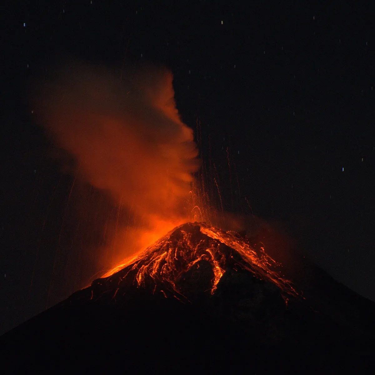
Fuego is classified as a stratovolcano with a long-lived Strombolian eruption style. The summit crater has been actively venting since the start of the current phase in 2002, which the Smithsonian GVP records as a single continuous eruption episode (VEI 3, 2002 to present).
Risk zone and evacuation routes
The map above plots the official 20 km risk radius as a dashed circle. Inside that radius sit the four communities at greatest exposure to ashfall, lahars, and (in the worst case) pyroclastic flows:
- Alotenango (Sacatepéquez) — closest to Fuego’s eastern flank, in the direct line of multiple drainages.
- San Miguel Dueñas (Sacatepéquez) — northeast of the volcano, periodically affected by ashfall.
- Antigua Guatemala (Sacatepéquez) — the major tourist hub at ~17 km. Historically only affected by light ashfall.
- Escuintla (Escuintla department) — southeast of the volcano, in the broader downstream zone for lahars carrying volcanic material during the rainy season.
CONRED maintains an evacuation route system fanning out from the high-risk Las Lajas, Honda, El Jute, and Trinidad barrancas (the south and southeast drainages — the ones that killed people in 2018). The official CONRED emergency line is 1566.
Eruption history
The table below pulls Fuego’s confirmed eruption history straight from the Smithsonian Global Volcanism Program dataset. Recent notable events:
- 2002-present (VEI 3) — current ongoing eruptive phase. Daily Strombolian explosions.
- 1974 (VEI 4) — one of the largest 20th-century eruptions in Central America; pyroclastic flows reached over 10 km from the summit.
- 1944, 1947, 1949 — VEI 2 events in the mid-20th century, part of an earlier active cycle.
The historic record stretches back to a confirmed eruption around 1580 BCE in the geological record.
How activity is monitored
INSIVUMEH operates a network of seismic stations on and around Fuego, plus visual observers at the Observatorio Vulcanológico Fuego (OVFGO) in Panimache and a thermal/visual camera feed. The agency publishes the Boletín Vulcanológico Diario — usually a 1-2 page Spanish PDF — most mornings around 6-8 AM local time. The bulletin lists:
- Number of explosions in the previous reporting period
- Ash column heights (in meters above the crater)
- Which drainages are receiving lava or ballistic blocks
- Ashfall reports from nearby communities
- The official alert level (Verde / Amarillo / Naranja / Rojo)
CONRED — Coordinadora Nacional para la Reducción de Desastres — sets the institutional alert that triggers evacuation orders. The alert system has four levels:
- Green (Verde) — normal background activity, no restrictions.
- Yellow (Amarillo) — elevated unrest, exercise caution.
- Orange (Naranja) — heightened potential for hazardous eruption, prepare for evacuation.
- Red (Rojo) — hazardous eruption imminent or underway, evacuate immediately.
Most of 2023-2026 Fuego has spent at Yellow with intermittent Orange pulses.
What to do if Fuego escalates
If you are within the 20 km risk radius and CONRED issues an Orange or Red alert:
- Stop hiking, drive, or transit toward the volcano immediately.
- Listen for sirens and CONRED community-radio announcements. Do not rely on social media alone.
- If pyroclastic flow alarm sounds, move perpendicular to the barranca direction — never down-valley. The 2018 disaster killed people who tried to outrun a flow down the same drainage.
- N95 masks, goggles, long sleeves for ash protection. Seal windows with damp cloth or tape.
- Stay out of river valleys for 48-72 hours after any significant ash deposition — lahars (volcanic mudflows) form during rainfall and travel faster than people can run.
- Emergency numbers: CONRED 1566, Bomberos 122, Ambulancia 128, Cruz Roja 125.
If you are in Antigua Guatemala, the realistic risks are light gritty ashfall and short-term flight delays at La Aurora airport. There has never been a tourist evacuation order for Antigua’s historic center.
Visiting near Fuego (safely)
Hiking Fuego is not allowed and not safe — it is an actively venting volcano with no safe summit route. The standard way to experience Fuego is from the Acatenango overnight expedition, where reputable operators guide hikers up to a base camp at 7-10 km from Fuego’s summit, across a deep barranca. The base camp delivers some of the most reliable volcanic shows on Earth: dozens of Strombolian explosions visible at night, often with audible booms a few seconds later.
For full safety, eruption history, and tour-cancellation guidance, see the Fuego Eruption Safety & Status guide and the Acatenango overnight hike guide. Cross-link to sibling pages: Pacaya live tracker and Santiaguito live tracker.
Watch Fuego erupt — safely, from Acatenango
Affiliate links — we earn a commission if you book, at no extra cost to you. Operators verified for safety records.
Related resources
- Guatemala volcano tracker (hub) — all three active volcanoes at a glance, with shared map.
- Pacaya live tracker — sibling page for Guatemala’s most accessible active volcano.
- Santiaguito live tracker — sibling page for the Quetzaltenango lava dome complex.
- Fuego eruption safety guide — what visitors actually need to know.
- Acatenango overnight hike — the safest, most reliable Fuego viewing experience.
- Guatemala weather & climate — rainy season impact on lahars and ash dispersion.
- Antigua Guatemala — the closest tourist hub to Fuego.