In short: Volcán de Fuego has been in a continuous Strombolian eruption since 2002. Small daily explosions are normal. The 2018 paroxysm that killed roughly 200 people in San Miguel Los Lotes was a rare large event, not typical activity. The official monitoring authority is INSIVUMEH; the disaster authority is CONRED. Alert levels are Green / Yellow / Orange / Red. Antigua (16-18 km away) and the Acatenango base camp at 7-10 km are safe viewing distances. Most of 2023-2026 has sat at Yellow. Tours typically run at Green and Yellow, pause at Orange, and shut down at Red. Verified May 2026.
Check Fuego's status before you travel
We are an independent guide and not affiliated with INSIVUMEH, CONRED, or the US Embassy. Always cross-check with the official source closest to the time you travel.
Volcán de Fuego is one of Central America’s most active volcanoes and a defining part of the landscape around Antigua. For visitors, the practical question is rarely “is it active?” — it almost always is — but how active, what alert level, and how close is too close. This guide explains how to read official status updates, what each alert level triggers in practice, what the 2018 disaster actually was, and where you can safely watch one of the most reliable volcanic shows on Earth.
Is Fuego erupting today?
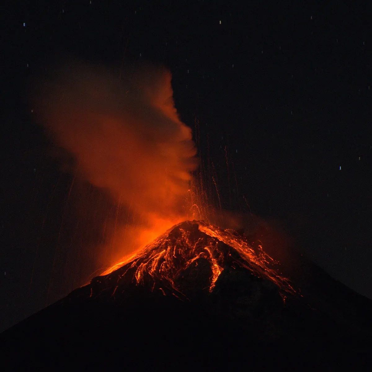
Yes — almost certainly. Fuego has been in continuous Strombolian eruption since 2002, producing on the order of 5-15 small explosions per day during typical activity. These explosions push ash columns a few hundred meters above the crater, send incandescent ejecta a short distance down the upper flanks, and produce audible booms heard from Antigua and Ciudad Vieja. Locals describe Fuego as “always working.” This is the baseline.
What changes day to day is the intensity: number of explosions per hour, height of ash columns, presence of lava flows in the upper drainages, and whether any pyroclastic density currents are reaching populated elevations.
The single best place to check is the INSIVUMEH Boletín Vulcanológico, published most mornings at insivumeh.gob.gt. The bulletin lists each monitored volcano by name with its current activity summary in Spanish — number of explosions in the last reporting period, ash column heights, drainages affected by ballistic blocks or lava, and the recommended public guidance.
If you don’t read Spanish, ask your hotel or your Acatenango operator that morning. Reputable operators in Antigua check the bulletin daily before deciding whether to run the tour.
What “eruption” means at Fuego
The word “eruption” carries different weight at different volcanoes, and Fuego is a case where the everyday meaning and the technical meaning don’t match.
In technical terms, an eruption phase at Fuego is a multi-year stretch of activity above background. Fuego’s current phase started in 2002. Within that phase, the volcano produces:
- Strombolian explosions — small to moderate ejections of gas and partially molten rock, several per hour during typical days. These are the booms you hear from Antigua.
- Ash columns — usually 300-1,500 m above the crater, occasionally higher during stronger pulses.
- Lava flows — short, slow flows down the upper barrancas (drainages), typically extending 0.5-2 km from the crater.
- Block-and-ash flows — occasional small avalanches of hot fragments down the same drainages.
What 2018 was — and what visitors actually fear — is a paroxysmal eruption: a much larger, faster event that produces a fast-moving pyroclastic density current capable of reaching populated areas. Paroxysms at Fuego are rare. Most years contain none. When they happen, they unfold over hours.
The honest framing: Fuego is constantly active and rarely dangerous to visitors at the standard viewing distance, with the caveat that “rarely” is not “never” and the 2018 event is the reason monitoring tightened.
Recent activity 2023-2026
Without inventing specific event dates, the broad pattern across recent years has been the long-running Strombolian baseline punctuated by occasional pulses of stronger activity lasting hours to a few days. INSIVUMEH has issued Special Bulletins (Boletín Especial) during these stronger pulses to flag elevated risk of lahars, ashfall, or pyroclastic activity in the upper drainages.
For trip planning, the takeaway is:
- The volcano is always active, so don’t expect a “safe window” of no activity — there isn’t one.
- The volcano is usually at Yellow alert, which is normal for an active volcano.
- Orange-level activity is uncommon and typically resolves within days.
- Red alerts trigger full closure of Acatenango and other approach routes.
Always read the last 7 days of INSIVUMEH bulletins before booking — they’re short and the trend matters more than any single day.
The 2018 disaster — what happened
On June 3, 2018, Fuego produced a paroxysmal eruption that generated a fast-moving pyroclastic density current down the Las Lajas drainage on the volcano’s southeast flank. The flow descended through the Las Lajas barranca, jumped its banks, and overran the community of San Miguel Los Lotes and parts of El Rodeo in the Escuintla department.
Official CONRED counts placed confirmed dead at approximately 200, with hundreds more reported missing. Many bodies were never recovered because the deposits were too hot to excavate for days and too deep to fully clear afterward. It is the deadliest single volcanic event in Guatemala since the 1902 eruption of Santa María.
What changed after 2018:
- Monitoring expanded. INSIVUMEH added seismic stations and gas measurement points on the south and southeast flanks. CONRED tightened its alert thresholds and evacuation protocols.
- Las Lajas became a watch drainage. Special bulletins now flag any indication that pyroclastic material is reaching the barranca’s middle and lower sections.
- Evacuation triggers shifted earlier. CONRED is now more willing to issue precautionary evacuations on Orange alerts in the southeast flank communities.
- Tour-operator culture shifted. Reputable Acatenango operators are now more conservative about running tours during stronger pulses, even at Yellow.
Critics in Guatemalan civil society have argued the 2018 evacuation order came too late and that warning systems for the affected communities were inadequate. Several civil and criminal cases addressing those failures remain in process. None of that changes how you use INSIVUMEH bulletins as a visitor today — the technical monitoring is much stronger than it was in 2018, and the alert system itself remains the authoritative signal.
How INSIVUMEH monitors Fuego
INSIVUMEH (Instituto Nacional de Sismología, Vulcanología, Meteorología e Hidrología) is Guatemala’s official volcano monitoring authority. For Fuego, the institute operates a multi-instrument network:
- Seismic stations ringed around the cone detect explosion signals, tremor (continuous shaking that often precedes stronger activity), and rockfalls in the drainages.
- Gas-measurement instruments track sulfur dioxide (SO₂) flux, a leading indicator of changes in the magma column.
- Thermal imaging — both from ground stations on Acatenango and satellite passes — detects hot spots, lava-flow advance, and pyroclastic material in the upper drainages.
- Visual observation posts on the Acatenango side and from observatories in Panimaché and Sangre de Cristo provide direct line-of-sight monitoring.
- Drone observation is used during stronger pulses to document crater morphology and confirm where material is being ejected.
INSIVUMEH coordinates with CONRED on the institutional alert level and with the Washington VAAC on ash advisories for aviation. The Smithsonian Global Volcanism Program publishes weekly summaries that aggregate INSIVUMEH and other sources for international researchers.
For visitors, you don’t need to interpret raw seismic data — INSIVUMEH already does that and publishes the result in the daily bulletin.
Alert levels and what they mean
Guatemala uses a four-level institutional alert scale managed jointly by INSIVUMEH (technical input) and CONRED (institutional declaration):
| Alert | Meaning | What it triggers |
|---|---|---|
| Green | Normal background activity. No elevated risk. | Normal life. Tours run. No evacuation advisories. |
| Yellow | Elevated unrest above normal. Stronger explosions, more ash, mild population guidance. | Tours typically still run. Communities in the southeast flank stay alert. Precautionary measures for vulnerable groups. |
| Orange | A stronger eruption appears likely in hours to days. Active danger zone defined. | Reputable tour operators pause or restrict routes. CONRED may issue precautionary evacuations in the southeast flank. Airspace advisories possible. |
| Red | A hazardous eruption is imminent or already underway. | Mandatory evacuation of designated zones. All volcano access closed. Airport closures possible. |
Most of 2023-2026, Fuego has spent at Yellow. Orange has occurred episodically during stronger pulses and typically resolved within days. Red alerts are reserved for paroxysmal events like 2018.
Safe distance for visitors
The simple rule: closer to the south or southeast flank below 2,500 m elevation is dangerous; everything else, in practice, is fine.
Concrete distances:
- Antigua (16-18 km from summit): safe. Shielded by Volcán de Agua. Worst-case impact is ashfall.
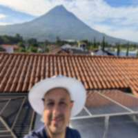
- Acatenango base camp (7-10 km across a deep barranca): safe. This is where every Acatenango overnight tour stops. Pyroclastic flows from Fuego travel southeast, away from this side.
- Ciudad Vieja, Alotenango (10-12 km): generally safe. These communities receive heavier ashfall and have evacuation plans for stronger alerts.
- El Rodeo, San Miguel Los Lotes drainage (less than 5 km on the southeast flank): the historic danger zone. This is where the 2018 flow killed people. Tourists do not visit here.
- Hiking on Fuego itself: not permitted as a tourist activity. Approach to the upper cone requires special INSIVUMEH approval and is reserved for monitoring and research, not recreation.
If you are watching from Acatenango base camp at night and an explosion looks bigger than the rhythm of the last hour, that is normal Strombolian variability. Your guide is monitoring the situation. The danger pattern is not “one big bang” — it’s sustained intensification over hours and tremor signatures only INSIVUMEH instruments can read.
When tours are cancelled
Reputable Acatenango and overnight Fuego-view operators (the $90-$150 USD tier on GetYourGuide and Viator) generally follow this protocol:
- Green and Yellow: tours run normally. This is the default.
- Orange: most operators pause the overnight or restrict to lower base camps that don’t have direct Fuego view. Some operators continue if the Orange is localized to a specific drainage that doesn’t affect the Acatenango route, but customers should expect cancellations.
- Red: all tours cancelled. The entire approach is closed by CONRED.
Refund policy varies. Most operators booked through GetYourGuide or Viator offer free cancellation up to 24 hours before departure regardless of weather or volcano status. After that, weather and volcano cancellations are typically handled as a reschedule, not a cash refund. Some budget operators (the $30-$50 trailhead-direct option) have no formal cancellation policy at all.
If volcanic activity is genuinely your concern, the cleaner protection is travel insurance with explicit volcanic-activity coverage — and you have to read the exclusions, because many travel policies treat Fuego as a known, pre-existing condition and decline claims for it.
For a price-and-operator comparison of overnight tours, see our Acatenango overnight hike guide.
Earthquake risks
Fuego is part of the broader Central American Volcanic Arc, where the Cocos Plate subducts beneath the Caribbean Plate offshore. The same geology that produces volcanoes produces earthquakes. Guatemala has a long history of damaging seismic events — the 1976 magnitude 7.5 earthquake that killed roughly 23,000 people is the most consequential in living memory.
For visitors, the practical points:
- Small earthquakes (M3-M4) are common and routine. You probably won’t feel most of them.
- Larger felt earthquakes happen periodically across the country.
- Volcanic and tectonic earthquakes are different in origin — volcanic-tremor signals are a monitoring signal for INSIVUMEH, separate from regional tectonic events.
- Drop-cover-hold is the standard recommendation indoors. Outdoors, move away from buildings, walls, and overhead wires.
INSIVUMEH publishes a separate seismic bulletin alongside the volcanic one. If a regional earthquake is large enough to affect tourists, the US Embassy and most major hotels in Antigua will push notifications within hours.
Ash impact on Antigua
Light ashfall in Antigua during stronger Fuego activity is not unusual. It looks like fine gray dust on car windshields, balcony tiles, and outdoor furniture. The grain size is small enough that you can wipe it off; coarser ash from very strong eruptions occasionally reaches Antigua but is rare.
Practical considerations:
- Wipe ash off solar panels and rooftops with a soft brush, not water (water turns fine ash into a slurry that’s harder to remove).
- Avoid driving with windshield wipers on a dusted windshield — dry ash is abrasive and will scratch glass. Use water from a spray bottle first.
- Vulnerable groups — asthmatics, people with COPD, infants, and pregnant women — should stay indoors during noticeable ashfall and consider an N95 or KN95 mask if going outside is unavoidable.
- Healthy adults generally tolerate light ashfall with no protection beyond avoiding strenuous outdoor exercise during heavier events.
Antigua’s hotels handle ashfall routinely. It is not, in itself, a reason to leave town.
Driving routes that may close
The CA-9 (Pan-American Highway) segment near Escuintla can experience short closures during stronger Fuego pulses if ash drifts across the road or if precautionary evacuations affect nearby communities. The southeast-flank access roads to El Rodeo, La Reunión, and the Las Lajas drainage are routinely closed during Orange and Red alerts.
The CA-1 route from Guatemala City to Antigua passes the eastern flank of Volcán de Agua and is not typically affected by Fuego activity. Antigua-to-Acatenango trailhead road access depends on the operator and the alert level.
If you are driving yourself in Guatemala during an active period, PROVIAL (the road-emergency service) and CONRED publish road closure updates. Most visitor itineraries do not pass through the danger zone — Antigua, Lake Atitlán, and Tikal-bound routes all avoid the southeast flank.
For hikers vs general tourists
The risk profile depends entirely on what you’re doing.
General tourists in Antigua — staying in hotels, walking the cobblestone streets, day-tripping to coffee farms or Lake Atitlán — have effectively zero direct Fuego exposure beyond occasional ashfall. The volcanic show is a feature, not a hazard. Sunset views from Cerro de la Cruz or from rooftop bars in Antigua’s center give you a long, safe view of the volcano without leaving the city.
Acatenango overnight hikers are at the next exposure level — closer to the volcano, sleeping at altitude for one night, traveling in steep terrain. Risks are dominated by altitude, cold, and trail injury, not by Fuego itself. A reputable guide and a sober read of the weather and alert level handles the volcano side; the rest is fitness and gear.
Hiking ON Fuego itself is in a different category and is not a tourist activity in 2026. Approaches to the upper cone are restricted, require INSIVUMEH coordination, and are reserved for monitoring and research personnel. If an operator offers to take you ON Fuego (not the Acatenango side, but Fuego’s own cone), treat it as a serious red flag.
Communication during eruption
If a stronger event is underway during your trip:
- Mobile networks in the Antigua-Sacatepéquez area generally stay up but can be congested. Have alternatives (WhatsApp over Wi-Fi at your hotel is often more reliable than cellular voice).
- Government alerts push to Guatemalan mobile numbers via SMS and through CONRED’s social channels — almost exclusively in Spanish. If you don’t read Spanish, follow the US Embassy English-language Twitter/X feed and ask your hotel’s reception desk.
- Air travel — La Aurora airport publishes status updates through the DGAC (Dirección General de Aeronáutica Civil) and individual airline channels. Check with your airline first; ash closures are typically short.
- Family abroad — message a single trusted contact when an event begins (“safe in Antigua, watching the news”) rather than letting silence amplify worry.
The CONRED emergency line is 1566. Other useful numbers: Bomberos Voluntarios 122, Ambulancia 128, Cruz Roja 125.
Insurance considerations
Travel insurance volcano coverage is the single biggest exception-strewn category in most policies. Things to check before you assume you’re covered:
- Does the policy explicitly mention volcanic activity or natural disasters as covered events, or is the language vague?
- Is Fuego (or “volcanoes in Guatemala”) listed under exclusions as a known pre-existing hazard? Some policies decline claims on the grounds that Fuego is continuously active and therefore not a “sudden, unexpected event.”
- What’s the trip-interruption coverage — does it cover a forced re-route or extra hotel nights if your flight is cancelled by ash?
- Is there medical evacuation coverage in case of injury during a hike?
- What does cancel-for-any-reason (CFAR) add? CFAR upgrades are the only reliable way to recover non-refundable trip costs if you decide not to go because of volcanic activity but no formal travel advisory exists.
The straightforward read: assume your standard travel insurance does not cover Fuego-related cancellation unless the policy explicitly says so, and budget accordingly.
Related guides
- Guatemala volcano tracker — live alert levels across Fuego, Santiaguito, and Pacaya
- Acatenango overnight hike 2026 — operator and price comparison
- Pacaya day hike with kids — the family-friendly Guatemala volcano option
- Antigua Guatemala travel guide — where most Fuego-watchers stay
- Guatemala safety overview 2026 — broader country safety context
- Our methodology — how we research and verify data
Sources: INSIVUMEH Boletín Vulcanológico (insivumeh.gob.gt), CONRED disaster authority (conred.gob.gt), Smithsonian Global Volcanism Program, Washington VAAC. This page is informational and not a substitute for official guidance. Always check INSIVUMEH and CONRED directly before traveling near an active volcano. Verified May 2026.