In short: The Acatenango overnight hike is a 2-day expedition to a base camp at roughly 3,600 meters on Guatemala’s fourth-tallest volcano (3,976m summit), positioned to watch Volcan de Fuego erupt every 15-30 minutes through the night across a 3-kilometer saddle. Most hikers go with operators from Antigua (8-10am pickup, return mid-afternoon the next day). Cost in 2026: roughly $35-80 budget, $80-150 mid-range, $200+ premium. The climb is strenuous — 1,500 vertical meters over 5-6 hours at altitude. Dry season (Nov-Apr) offers clearest Fuego views. A certified guide is mandatory per CONRED and INGUAT regulations. Verified May 2026.
The Acatenango overnight hike is the single most photographed adventure in Guatemala. It’s not a casual day trip — it’s a real high-altitude expedition that puts you on a sleeping pad at 3,600 meters in near-freezing wind, watching a 3,763-meter volcano spit lava across the sky every 15-30 minutes for hours on end. This guide covers when to go, how to pick an operator, what to pack, how altitude affects you, Fuego safety, photography, and an honest cost breakdown. For broader context see our volcano tracker, the Pacaya day hike alternative, and Fuego eruption safety status.
Book your Acatenango overnight hike
Affiliate links — we earn a commission if you book, at no extra cost to you. Booking deadline reminder: from late November through early April, popular operators sell out 1-3 weeks ahead, especially on weekends.
Why Acatenango Overnight Is the Iconic Guatemala Hike
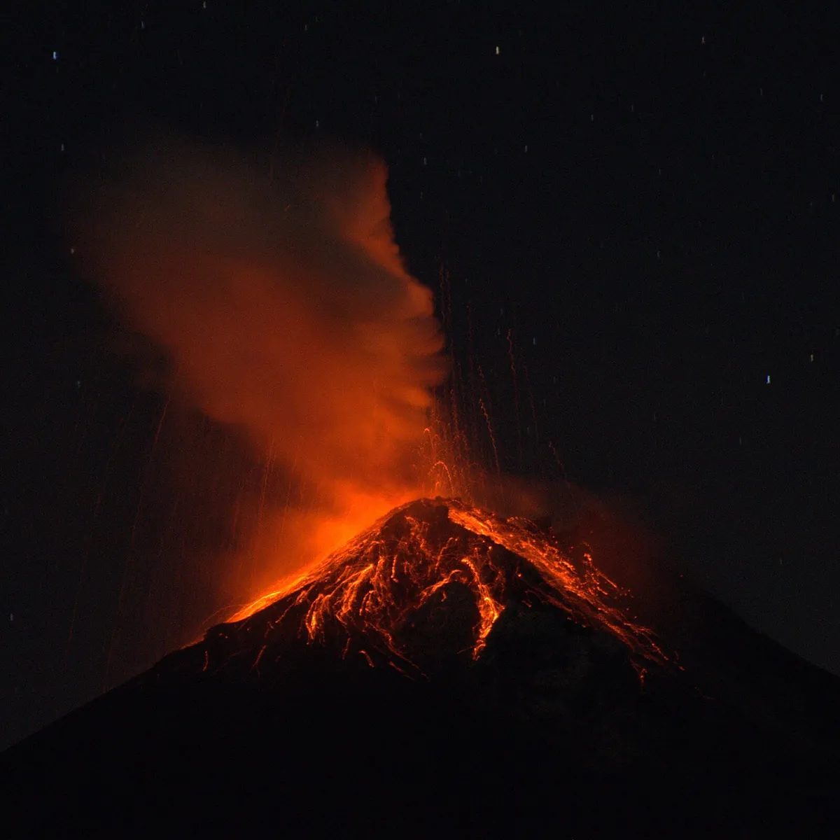
Acatenango is a calm dormant cone positioned 3 kilometers across a saddle from one of the most active volcanoes on Earth — a viewing platform built into the mountain by topography. Fuego (3,763m) has been in near-continuous Strombolian eruption since 2002. INSIVUMEH typically logs 5-15 explosive bursts per night. From base camp on Acatenango’s western flank you watch each eruption send glowing lava bombs hundreds of meters into the air, hear concussive booms 20-40 seconds after each blast, and feel the rumble.
The altitude makes it serious. Trailhead 2,400m, base camp 3,600m, summit 3,976m. AMS affects roughly one in four climbers at this altitude regardless of fitness.
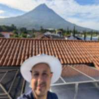
The proximity to Antigua is unmatched. Most spectacles of this scale require days of travel from remote airports. Acatenango is 90 minutes by van from Antigua, which is 60 minutes from Guatemala City’s airport. Fly in one morning and be at base camp watching Fuego erupt 48 hours later.
When to Go: Best Season and 2026 Calendar
Dry season (Nov-Apr) is recommended: clearer Fuego visibility, more stable trail conditions, but coldest base-camp nights (Dec and Jan routinely drop to 0-5C at 3,600m). Best Fuego viewing months: December, January, February. Best balance of comfort and visibility: late November and mid-February.
Rainy season (May-Oct) brings cloud cover parked directly over Fuego, slippery descents, and afternoon lightning. May and October are most tolerable; July-September are hardest for clear views.
| Period | Crowds | Booking lead time | Notes |
|---|---|---|---|
| January | High | 2-3 weeks | Post-holiday peak, clear skies |
| February | Mod-High | 1-2 weeks | Cool, clear, peak photography conditions |
| Mar 22 - Apr 6 (Semana Santa) | Extreme | 3-4 weeks | Antigua-wide tourism surge |
| April | Moderate | 1-2 weeks | Last reliable dry days |
| May | Low-Mod | 1 week | Transition, rain starts |
| Jun-Sep | Low | 2-7 days | Rainy season, cloudier views |
| October | Moderate | 1-2 weeks | Drying out |
| November | Mod-High | 1-2 weeks | Clear skies return |
| Dec 15 - Jan 5 | Extreme | 3-4 weeks | Coldest base-camp nights |
Difficulty Assessment: An Honest Take
Acatenango is regularly described as “moderate” in travel listings. That’s marketing — it’s strenuous.
- Vertical gain: ~1,500m one way, about 1.5x Half Dome’s vertical compressed into shorter horizontal.
- Trail surface: first hour cornfields (fine). Middle 2 hours sandy switchbacks through cloud forest — the surface acts like a slow-motion treadmill. Final 1-2 hours steep and exposed above the treeline.
- Altitude factor: at 3,600m base camp, air pressure is ~65% of sea level. Aerobic capacity drops 20-30% for non-acclimatized hikers — the dimension underestimated most.
- Cold factor: base camp near freezing in dry season. Sweat-soaked cotton is dangerous if you don’t change to dry layers on arrival.
- Honest fitness baseline: if you can hike uphill 5 hours at sea level with a 6-10 kg pack and feel tired but not destroyed, you can finish Acatenango. If not, train 6-8 weeks first or skip the summit add-on.
| Component | Acatenango | Comparison |
|---|---|---|
| Vertical gain | ~1,500m | Mount Washington: ~1,300m |
| Time climbing | 5-7 hrs | Half Dome cables: 5-7 hrs |
| Max altitude | 3,976m | Mount Whitney: 4,421m |
| Trail surface | Volcanic sand and dirt | PCT typical: dirt and rock |
| Technical skill | None | None |
| Honest difficulty | Strenuous | Half Dome: “strenuous” |
Tour Operators: What to Look For
Operator quality varies widely. Evaluate on these dimensions before booking:
- Guide-to-hiker ratio. Premium operators run 1:6-8. Budget operators sometimes go 1:15-20 — if someone develops AMS the group either waits indefinitely or pushes on unsupervised.
- Sleeping bag rating. Base camp drops below freezing in dry season. A 3-season bag rated to 5C is dangerous in January. Premium operators provide 4-season bags rated to -10C or lower.
- Tent quality. Wind at 3,600m is severe. Cheap dome tents flap and leak heat. Premium operators sometimes use insulated wooden shelters — quieter and warmer.
- Food. Hot dinner and breakfast are standard at the $80+ tier. The cheapest tours sometimes serve cold sandwiches — rough at 3,600m in wind after 6 hours of climbing.
- Group size cap. Smaller groups (6-12) move at more consistent paces. Groups of 20+ often split into fast and slow subgroups.
- Fuego summit add-on. Optional pre-dawn traverse closer to the active cone, typically $20-50 extra. Weather- and CONRED-dependent.
- Cancellation policy. Free cancellation 24-72 hours before departure is standard. Avoid non-refundable unless you have travel insurance.
- Reviews. Cross-reference Viator, GetYourGuide, and Google. Look for consistent recent feedback on guide competence, sleeping bag warmth, food, and safety during weather changes.
What’s Included in Tours vs DIY
Standard tour ($80-150): Antigua ↔ La Soledad transport, certified bilingual guide, Q100 entry permit, tent and sleeping bag rental, pad, hot dinner and breakfast, trail snacks, water. Trekking poles usually loaned. Day-pack porter typically a $30-60 add-on.
Premium ($150-250) adds: 4-season sleeping bags, insulated cabin shelters, gourmet meals, smaller groups (4-8 hikers), personal porter, Fuego summit traverse, hot chocolate or wine.
DIY (legal but harder): you still need a certified guide (solo hiking is prohibited). Arrange your own transport, pay the Q100 entry permit at the trailhead, hire a guide directly (Q200-400 / $26-52 per hiker), carry your own tent, bag, food, water, stove. DIY makes sense for experienced trekkers with their own gear. For most travelers the bundled tour costs the same or less once gear rental is factored in.
Packing List
Mandatory clothing (layered system): wicking base layer (synthetic or merino), insulating mid-layer (fleece or light down), heavy down jacket rated for sub-freezing, waterproof shell, hiking pants (not cotton), long underwear bottoms for sleeping, beanie, insulated gloves, wool socks (2 pairs), buff or neck gaiter.
Footwear: hiking boots with ankle support (not sneakers — volcanic sand fills them). Gaiters if you have them.
Gear: headlamp plus a spare set of batteries, 3 liters of water, 30-40L daypack, trekking poles (operators rent these), sunglasses, SPF 30+ sunscreen and lip balm, toilet paper / wet wipes in a sealed bag, a small trash bag (Leave No Trace is enforced), and small-bill cash (Q50-100) for tips and extras.
Optional but recommended: camera with extra batteries (cold kills them fast), tripod for long-exposure Fuego shots, power bank, chemical hand warmers (especially Dec-Feb), thermos, calorie-dense snacks (you’ll burn 4,000+ calories on day 1).
Don’t bring: cotton anything (it traps sweat and conducts heat away from your body), heavy electronics you won’t use, more than 3L of water, glass.
Photography Tips
Three primary photo opportunities:
- Long-exposure Fuego eruptions after dark — the iconic shot. Tripod (or stable rock), manual mode, starting at f/2.8-4, ISO 800-1600, shutter 8-20 seconds. Open the shutter when glow starts at the Fuego summit, hold through the arc, close when lava settles. Bracket exposures.
- Golden hour at base camp — the hour before sunset, the Fuego cone catches warm light from the west. Aperture priority around f/8, ISO 200-400. Polarizing filter cuts haze.
- Sunrise from the Acatenango summit (optional push) — sea of clouds fills the valleys below with Fuego poking through. Wide lens (16-35mm equivalent), f/8-11, bracket.
Phone photography: Night Mode on, stabilize against a rock, tap-and-hold the Fuego summit to lock focus, drop exposure 1-2 stops to preserve the glow.
Cold-weather caveats: batteries die fast below freezing — carry spares in an inner pocket. Condensation forms on lenses when a cold camera enters a warm tent; keep it bagged for 20 minutes after entering shelter.
Altitude Sickness: What to Expect
Acute mountain sickness (AMS) affects roughly 25% of hikers at 3,600m regardless of age or fitness — elite runners get hit, couch potatoes sometimes feel fine. Plan for it.
Mild symptoms (manageable): headache, mild nausea, trouble sleeping, fatigue beyond what the climb justifies, mild shortness of breath at rest, dizziness on standing.
Severe symptoms (descend immediately): confusion, ataxia (loss of coordination), persistent vomiting, gurgling in the chest (possible HAPE), severe headache unresponsive to ibuprofen, cyanosis, extreme breathlessness at rest.
Prevention: 1-2 nights in Antigua (1,500m) first to start acclimatizing, 3-4 liters of water the day before, no alcohol, high-carb dinner, climb slowly, eat steadily on the trail.
Medications: Acetazolamide (Diamox) is the standard prophylactic — prescription-only in the US but over the counter at most Antigua pharmacies. Typical dose: 125mg twice daily starting the day before ascent. Discuss with your doctor if you have sulfa allergies or kidney conditions.
When to turn back: at any severe symptom, descend immediately. Dropping 300-500 vertical meters typically resolves AMS within hours. Most operators carry pulse oximeters and supplemental oxygen. Tell your guide the moment something feels off.
Safety and Volcan Fuego Eruption Status
Acatenango itself is dormant — geologically stable for the duration of your hike. The safety conversation is about Fuego.
Fuego’s behavior: continuous Strombolian eruptions since 2002 with occasional larger paroxysms. The June 3, 2018 paroxysm killed 400+ people in San Miguel Los Lotes on Fuego’s southern flank — the deadliest volcanic disaster in Guatemala since 1902. INSIVUMEH monitors Fuego continuously with seismometers, gas sensors, and thermal cameras.
Why base camp is safe: Acatenango’s western flank is separated from Fuego by a deep saddle, roughly 3km from the cone, outside the pyroclastic flow zone (flows travel down Fuego’s slopes, not up Acatenango’s). The 2018 disaster killed people in valleys below Fuego, not on Acatenango. CONRED would close the route if base camp ever fell within a danger zone.
4-level alert system: Green (tours operate normally), Yellow (tours typically continue with monitoring), Orange (Fuego summit options often suspended), Red (all routes closed). Check current Fuego status the morning of your hike via INSIVUMEH’s daily bulletins.
Other hazards: lightning during rainy-season afternoon storms; hypothermia (the most common serious hazard — stay dry, layer before stopping, eat regularly); slippery volcanic-sand descents (trekking poles prevent most stumbles); no significant wildlife above 3,000m.
Day Before: Arriving in Antigua
Most hikes depart Antigua at 8-10am, so arriving the day before is non-negotiable. Antigua’s 1,500m elevation begins the acclimatization process. The evening before, reputable operators run a gear check, issue rented gear, and brief the schedule. Restock anything missing along 5a Avenida Norte (outdoor stores) and 4a Calle (pharmacies — acetazolamide over the counter). Drink 3-4 liters of water, eat a high-carb dinner, skip alcohol, sleep early. See our Antigua neighborhood guide for lodging.
Day-Of Itinerary: Pickup to Base Camp
A mid-range operator’s typical schedule:
| Time | Stage | Notes |
|---|---|---|
| 6:30-7:30am | Breakfast at your Antigua hotel | Eat substantially — eggs, fruit, toast |
| 8:00-9:00am | Pickup and drive to La Soledad | 30-90 min van ride |
| 9:30-10:30am | Trailhead briefing, gear distribution | Final safety brief, permits paid |
| 10:30am-12:30pm | Section 1: Cornfields and farmland | Gentle to moderate grade |
| 12:30-1:30pm | Lunch break at first viewpoint | Volcan de Agua and Pacaya visible |
| 1:30-4:00pm | Section 2: Cloud forest switchbacks | The hardest part — volcanic-sand treadmill |
| 4:00-5:30pm | Section 3: Above the treeline | Wind picks up, Fuego appears |
| 5:30-6:00pm | Arrive base camp | Change into dry layers immediately |
| 6:00-7:00pm | Hot dinner | Pasta, soup, or rice with protein |
| 7:00pm-late | Fuego eruption show | Sunset ~6:15pm; eruptions vivid in the dark |
Summit Day (Optional Pre-Dawn Fuego Push)
About a third of overnight hikers add the optional pre-dawn push. Wake-up 3:30-4:00am at base camp, departure 4:00-4:15am with headlamps essential.
Two route variations: the Acatenango summit option is 2-3 hours climbing on steep volcanic sand to 3,976m for a 6:30-7:00am sunrise — views span the entire highlands (Atitlan volcanoes west, Pacaya south, Agua east, Tajumulco on clear days). The Fuego traverse is 1.5-2 hours along the saddle ridge to a CONRED-approved vantage point within 1-2km of the active cone — eruption shockwaves are visceral. You never summit Fuego itself (lethal). Verify with your operator which route they run.
Skip the add-on if you slept poorly, have AMS symptoms, or weather has turned (wind over 30 mph or rain). Wind chill at the summit can hit -10C when base camp is 5C. Descent back to base camp takes 1-1.5 hours.
Return to Antigua and Recovery
Breakfast at base camp ~7:30am, descent starting 8:30am, 2-3 hours back down to La Soledad on sliding volcanic sand (knees take the beating going down), arriving in Antigua mid-afternoon. Long shower, eat real food, hydrate, sleep 9-10 hours. Sore quads and knees for 2-3 days are normal. Plan a low-key day after — Antigua’s coffee shops and restaurants are perfect.
Costs Breakdown
Approximate total per person, 3-night Antigua stay:
| Item | Budget | Mid-range | Premium |
|---|---|---|---|
| Overnight tour package | $35-50 | $80-130 | $150-250 |
| Antigua lodging x 3 nights | $30-60 | $90-180 | $250-500 |
| Antigua food (3 days) | $30-50 | $60-100 | $120-200 |
| Gear rental (if needed) | $15-25 | $20-30 | $30-50 |
| Tips (guide + porter) | $15-25 | $25-40 | $50-80 |
| Airport-to-Antigua transport | $15-25 | $20-30 | $40-80 |
| Acetazolamide (if used) | $5-10 | $5-10 | $5-10 |
| Buffer / extras | $20 | $40 | $80 |
| Total per person | $165-265 | $340-560 | $725-1,250 |
Mid-range all-in of $400-500 per person is realistic for most travelers. Couples sharing lodging cut per-person cost meaningfully. Add travel insurance covering trip cancellation and emergency evacuation ($30-80 for the week).
Acatenango vs Pacaya vs Fuego (Technical Comparison)
| Volcano | Status | Altitude | Hike type | Difficulty | Time | Cost |
|---|---|---|---|---|---|---|
| Pacaya | Active (intermittent) | 2,552m | Day hike | Easy-moderate | 5-6 hrs | $24-96 |
| Acatenango | Dormant | 3,976m | Overnight | Strenuous | ~24 hrs | $35-250 |
| Fuego | Very active (since 2002) | 3,763m | Not a standalone hike (lethal) | — | — | Add-on only |
| Volcan de Agua | Dormant | 3,766m | Day hike | Strenuous | 6-8 hrs | $30-80 |
| Tajumulco | Dormant | 4,220m | Overnight | Strenuous | 2 days | $50-150 |
| Santa Maria | Dormant | 3,772m | Day hike | Very strenuous | 8-10 hrs | $40-80 |
Pacaya is the gateway — start there if you’ve never hiked an active volcano. Acatenango is the headliner. Fuego is the show, never the destination — you watch it, you don’t climb it. For current alert levels, see the volcano tracker.
Stories From Past Hikers (General Patterns)
Drawn from review aggregations across Viator, GetYourGuide, Reddit r/Guatemala, and TripAdvisor, these are the patterns that repeat:
- Many hikers describe the cloud forest switchbacks as the hardest section — the volcanic-sand treadmill that saps morale around hour 3.
- Many hikers describe their first sight of Fuego erupting as more emotional than expected — exhaustion plus altitude plus raw spectacle compounds.
- Many hikers regret skipping training and underestimating the climb.
- Many hikers regret cheap operators — cold nights from inadequate sleeping bags and large uncoordinated groups dominate sub-$50 reviews.
- Many hikers wish they had brought chemical hand warmers, especially Dec-Feb.
- Many hikers regret not staying longer in Antigua. A 1-day buffer on each side dramatically improves the trip.
Related Guides
- Guatemala volcano tracker — live alert levels and monitoring data
- Fuego eruption safety status and historical eruption patterns
- Pacaya day hike with kids — the easier alternative
- Antigua Guatemala — neighborhood and lodging guide
- Antigua restaurants — where to eat before and after your hike
- Tikal multi-day itinerary — pair your volcano trip with Mayan ruins
- Our research methodology — how we verify operators, costs, and safety information