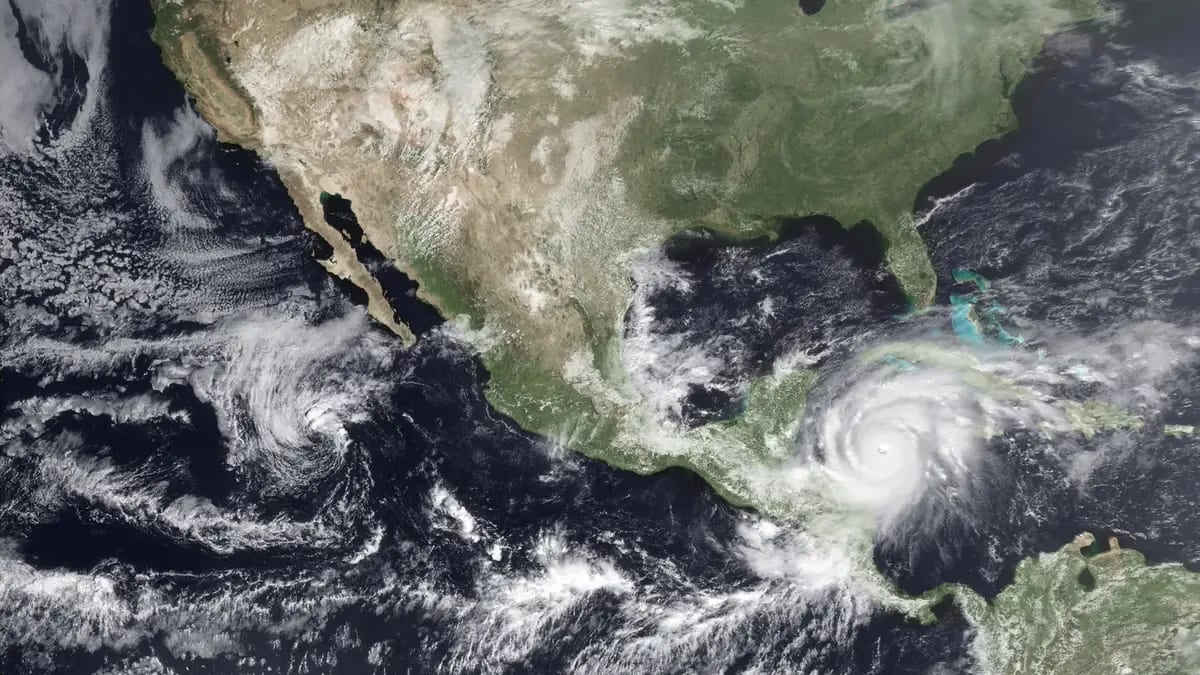
The 2026 Atlantic hurricane season is underway (June 1 – November 30). On June 11, 2026, NOAA’s Climate Prediction Center declared a full El Niño Advisory: El Niño conditions are present, expected to strengthen into winter 2026-27, with a 63% chance of a very strong event at the November-January peak. That matters for Guatemala because El Niño is the single biggest seasonal lever on Atlantic hurricane activity — and it usually pushes activity down.
Colorado State University’s April 9, 2026 forecast lines up with the El Niño expectation: 13 named storms, 6 hurricanes, 2 major hurricanes. NOAA’s official outlook publishes on May 21, 2026. This guide pulls all of it together — the forecasts, the El Niño mechanism, Guatemala’s full historical hurricane record back to 1851, and where in the country actually faces real risk.
Quick summary: Atlantic hurricane season runs June 1 – November 30, 2026. Peak is mid-August through late October. NOAA’s El Niño Advisory (declared June 11; conditions present, 63% chance very strong) typically suppresses activity, and CSU’s first forecast calls for a below-average season (~75% of the 1991-2020 normal). Since 1851, 32 Atlantic hurricanes have passed within 200 km of Guatemala’s centroid. The Caribbean coast (Izabal) and northern Petén carry the highest direct risk. The deadliest Atlantic system in modern memory was Mitch (1998) — its rainfall, not its winds, was the killer.
Explore the data: See the live forecast for all 22 departments at the Guatemala Weather Hub. The site also tracks active Atlantic storms during the season, the El Niño / La Niña state from NOAA CPC, and 30-year-normal rainfall comparisons by department. Refreshed every 15-30 minutes from official sources (NOAA NHC, INSIVUMEH, Open-Meteo).
The 2026 Forecast: Three Independent Calls, One Story
Three respected forecasting groups have published 2026 Atlantic outlooks ahead of the season. They mostly agree on the direction (below average) but disagree on the magnitude.
| Group | Date | Named Storms | Hurricanes | Major Hurricanes | Driver |
|---|---|---|---|---|---|
| CSU (Klotzbach) | April 9, 2026 | 13 | 6 | 2 | El Niño expected |
| TSR (Tropical Storm Risk) | April 2026 | Slightly below normal | — | — | El Niño expected |
| University of Arizona | April 2026 | 20 | 9 | 4 | Possible strong El Niño still leaves warm Atlantic SST in play |
| 30-year average (1991–2020) | — | 14 | 7 | 3 | Baseline |
| NOAA NHC | May 21, 2026 | TBD | TBD | TBD | TBD |
Source: Colorado State University Tropical Weather Forecast, April 2026 | CSU news release, April 9, 2026 | NOAA media advisory
CSU also publishes the probability of a major hurricane making landfall on the U.S. coast. For 2026 they call it at 32% for the entire U.S. coastline (vs the 43% long-term average), 15% for the East Coast and Florida (avg 21%), and 20% for the Gulf Coast (avg 27%). They will update the forecast on June 10, July 8, and August 5.
The CSU and TSR forecasts both pin El Niño as the dominant 2026 factor. The University of Arizona forecast is an outlier — it argues that even with El Niño, the Atlantic Main Development Region sea-surface temperatures remain warm enough to fuel storms, similar to 2023. NOAA’s May 21 outlook will be the tiebreaker.
El Niño and Atlantic Hurricane Suppression
The mechanism is well documented. During El Niño, the equatorial Pacific warms, which strengthens upper-level westerly winds across the Caribbean and tropical Atlantic. Those winds create vertical wind shear — the difference between wind speed and direction at the surface vs the upper troposphere. Hurricanes need a relatively calm, vertically stacked column to organize. Strong wind shear tears developing storms apart.
NOAA’s June 11, 2026 ENSO Diagnostic Discussion declared an El Niño Advisory: conditions are present (weekly Niño-3.4 at +0.7°C, coastal Niño-1+2 at +2.1°C) and forecast to strengthen into winter 2026-27, with a 63% chance of a very strong event during November-January — which would rank among the largest El Niño events since 1950. For hurricane suppression purposes, that is the strongest possible version of this signal.
Historical evidence for the El Niño / Atlantic suppression link:
- 1997 El Niño season: 8 named storms, 3 hurricanes, 1 major hurricane. One of the quietest Atlantic seasons in modern records.
- 2015 El Niño season: 11 named storms, 4 hurricanes, 2 major hurricanes. Below long-term average.
- 2023 (Atlantic anomaly): 20 named storms despite developing El Niño — driven by record-warm Atlantic SST that overrode the shear suppression. This is the scenario the University of Arizona forecast is worried about for 2026.
The takeaway: El Niño usually suppresses, but it does not guarantee a quiet season. Atlantic SST has to cooperate too.
For the full ENSO context — including how El Niño affects Guatemala’s own rainy season and canícula — see the Guatemala El Niño / La Niña explainer.
Historical Hurricanes Near Guatemala (1851–2024)
The NOAA HURDAT2 database — the authoritative reanalysis of every known Atlantic hurricane back to 1851 — records 32 storms whose track passed within 200 km of Guatemala’s centroid (15.78°N, 90.23°W). That works out to roughly one near-miss every 5-6 years. The full filtered dataset lives in the site’s hurricane data feed.
Here are the top 10 by impact — hurricanes (Category ≥ 1) that came within 100 km, plus Mitch:
| Rank | Year | Name | Peak Category | Peak Winds (mph) | Closest Distance to GT |
|---|---|---|---|---|---|
| 1 | 2001 | Iris | Cat 4 | 144 | 58.5 km |
| 2 | 1961 | Hattie | Cat 5 | 167 | 69.0 km |
| 3 | 1969 | Francelia | Cat 2 | 98 | 65.5 km |
| 4 | 1934 | Unnamed | Cat 2 | 98 | 64.6 km |
| 5 | 1932 | Unnamed | Cat 4 | 144 | 64.6 km |
| 6 | 1949 | Unnamed | Cat 2 | 109 | 75.7 km |
| 7 | 2020 | Nana | Cat 1 | 75 | 45.8 km |
| 8 | 1945 | Unnamed | Cat 1 | 92 | 34.7 km |
| 9 | 2007 | Felix | Cat 5 | 173 | 111.8 km |
| 10 | 1978 | Greta | Cat 4 | 132 | 113.9 km |
| Bonus | 1998 | Mitch | Cat 5 | 178 | 133.5 km |
Source: NOAA Hurricane Research Division HURDAT2 reanalysis, hurdat2-1851-2024-040425.txt. All distances measured from track points to Guatemala centroid.
Notes on the table:
- Iris (2001) is the closest pass by a Category 4+ Atlantic hurricane. It made landfall in Belize as a Cat 4 and weakened over Petén.
- Hattie (1961) is one of only three Atlantic Cat 5s on record to come within 100 km of Guatemala. It devastated Belize City.
- Mitch (1998) ranks #11 by distance but #1 by Guatemalan impact. Its peak winds had dropped by the time it neared Guatemala (35 mph TD status), but the rainfall was historic.
- The 1945 unnamed hurricane is the closest documented approach in the record at 34.7 km — almost certainly a direct strike on Izabal or eastern Petén.
The Worst: Mitch (1998), Stan (2005), Eta + Iota (2020)
Here is the caveat that matters most for honest historical reporting: wind-track distance is a poor proxy for impact in Guatemala. Three of the deadliest hurricane-related disasters in modern Guatemalan history were caused by storms whose centers never came within 200 km of the country — but whose rainfall did catastrophic damage. They are not in the table above because they fall outside the HURDAT2 200 km filter. They still matter.
Hurricane Mitch — October–November 1998
- Peak intensity: Cat 5, 178 mph winds (over the western Caribbean)
- Closest pass to Guatemala: 133.5 km (as a weakened tropical depression)
- Guatemalan death toll: 268 (Guatemalan government), some estimates over 400
- Damage estimate: $748 million (1998 USD)
Mitch’s winds had collapsed by the time it neared Guatemala, but it dumped historic rainfall across the country. Honduras was hit hardest (over 10,000 deaths), but Guatemala suffered massive flooding in the Motagua and Polochic river basins, landslides in Alta Verapaz, and infrastructure destruction across the eastern half of the country. Source: USGS Mitch case study | IFRC Mitch appeal report.
Hurricane Stan — October 2005
- Peak intensity: Cat 1, 80 mph winds
- Center never came within 200 km of Guatemala — landed in Veracruz, Mexico
- Guatemalan death toll: Over 1,500 (Guatemalan government, including 600+ in the Panabaj/Santiago Atitlán landslide)
- Damage: Over $983 million
Stan is the deadliest weather event in modern Guatemalan history, and the storm itself was barely a hurricane. What killed people was an extended period of heavy rain in already-saturated mountainsides, triggering a massive landslide that buried the village of Panabaj on the shore of Lake Atitlán. Stan is a textbook case of the rainfall-vs-wind distinction: a weak hurricane in Mexico, a national tragedy in Guatemala. Source: NOAA Stan TCR | BBC Stan coverage.
Eta and Iota — November 2020
- Eta peak: Cat 4, 150 mph; Iota peak: Cat 4, 155 mph
- Both made landfall in Nicaragua, 15 days apart, in nearly identical locations
- Guatemalan death toll: ~60 (Eta + Iota combined, mostly from the Quejá landslide in Alta Verapaz)
- Displaced: Over 300,000 across Guatemala
Eta and Iota are the modern analog of Stan. Neither storm came close to Guatemala on the HURDAT2 track, but the back-to-back rainfall onto already-saturated ground triggered the Quejá landslide in Alta Verapaz on November 5, 2020, burying dozens of homes. Iota two weeks later compounded the flooding. Source: NOAA Eta TCR | NOAA Iota TCR | ReliefWeb Quejá coverage.
Why this caveat matters: if you read our historical table and conclude that hurricanes rarely affect Guatemala, you would be wrong. The table captures direct wind threat. It misses the rainfall threat — which has historically been deadlier. Any Atlantic hurricane that tracks through Honduras, Nicaragua, or southern Mexico can saturate Guatemala’s mountains and trigger landslides days later.
Where in Guatemala Faces the Most Risk
Atlantic hurricane risk in Guatemala is not evenly distributed. Three zones carry distinct profiles:
Caribbean Coast: Izabal Department
- Río Dulce, Livingston, Puerto Barrios
- Highest direct-strike risk in the country. Sits on the Caribbean Sea, directly in the path of any westward-tracking storm from the central Atlantic.
- Storms that have come closest: Iris (2001, 58 km), Nana (2020, 45 km), unnamed 1945 (34 km).
- Vulnerability: Low elevation, coastal flooding, riverine flooding from the Motagua and Polochic rivers, landslides on the Sierra del Mico.
Northern Petén
- Flores, Tikal, Sayaxché, Poptún
- Second-highest direct risk. Inland but exposed to storms that cross the Yucatán Peninsula or track through Belize.
- Storms that hit hardest: Felix (2007), Greta (1978), Hattie (1961) — all Yucatán-tracking systems whose outer bands or weakening eyewall passed over Petén.
- Vulnerability: Flooding of the Pasión and Usumacinta river basins, road washouts on dirt roads, isolation of remote villages.
Alta Verapaz and the Eastern Mountains
- Cobán, Tactic, the Polochic valley
- Indirect risk dominates. Not in the direct path, but receives heavy rainfall from any Atlantic storm that approaches the country.
- Storms that hit hardest: Stan (2005), Eta (2020), Iota (2020), Mitch (1998).
- Vulnerability: This is landslide country. The Quejá disaster (2020) and Mitch’s worst Guatemalan damage both occurred here. Saturated steep slopes + extended rain = landslides.
Pacific Coast and Western Highlands
- Escuintla, Retalhuleu, Quetzaltenango, Huehuetenango
- Lowest Atlantic-hurricane risk. Pacific storms (Eastern Pacific basin) can affect this coast, but they are separate from Atlantic systems and out of scope for this guide.
- The western highlands occasionally see heavy rain from Atlantic remnants but are protected by the Sierra Madre cordillera.
2026 Hurricane Season Timeline
| Period | Atlantic Activity | Guatemala Watch Points |
|---|---|---|
| June 1 – July 15 | Slow start typical. First named storms usually form in the Gulf or western Caribbean. | Cape Verde systems not yet active. Low direct risk for GT. Coincides with rainy season ramp-up. |
| July 16 – August 15 | Activity climbs. First “Cape Verde” storms form in the eastern Atlantic. | Canícula often suppresses local rain in GT (mid-July to early August). Monitor systems crossing the Lesser Antilles. |
| August 16 – September 30 | Peak season. September 10 is the climatological peak. Most major hurricanes form in this window. | Highest direct-strike risk for Caribbean coast and Petén. Indirect rainfall risk for all of eastern GT. |
| October 1 – October 31 | Activity stays high in the western Caribbean. Storms favor curving northward toward Yucatán/Florida, but western-Caribbean late-season systems are the most dangerous for Central America. | Highest historical risk window for Guatemala. Iris (Oct 9, 2001), Mitch (Oct 22–Nov 9, 1998), Stan (Oct 2005), Hattie (Oct 31, 1961) all hit in October. |
| November 1 – November 30 | Activity winds down. Most storms are weaker tropical storms. | Risk drops but not zero. Eta and Iota both struck in November 2020. The 1971 hurricane Laura passed within 58 km of Guatemala on November 22. |
The single highest-risk window in Guatemala’s record is late October through mid-November. That is when both Mitch and Iris struck, and when the deadliest combination of season-end Caribbean intensity + already-saturated soils + landslide-prone mountains lines up.
Preparedness: What Residents and Visitors Should Do
Guatemala’s national disaster agency is CONRED (Coordinadora Nacional para la Reducción de Desastres). Their emergency line is 119. Their public alerts are issued daily during high-risk weather and posted on social media. Save these:
- CONRED emergency: 119 (national) or 1566 (alternate)
- CONRED website: conred.gob.gt — official alerts, evacuation routes, shelter locations
- INSIVUMEH forecasts: insivumeh.gob.gt — daily weather bulletins for all 22 departments
- NOAA NHC active storms: nhc.noaa.gov — official Atlantic forecasts
For Residents
- Know your zone’s risk level. Caribbean coast and Petén = direct wind risk. Mountains = landslide risk. Cities = urban flood risk.
- Keep a 72-hour kit. Water (1 gallon per person per day), non-perishable food, flashlight, batteries, first aid, medications, important documents in waterproof bag, cash in small bills.
- Sign up for CONRED alerts via their official Twitter/X and Facebook accounts.
- Identify your evacuation route in advance. Especially if you live in Izabal, low-lying Petén, or on a steep hillside in Alta Verapaz, Sololá, or the volcanic chain.
For Visitors
- Check the Guatemala Weather Hub for active Atlantic storms during your trip.
- Travel insurance is a good idea for trips in September–November. Hurricane-related cancellations are not always covered by basic policies — read the fine print.
- Avoid Caribbean coast lodging (Río Dulce, Livingston) during peak storm activity. The 48-hour cone is reliable enough to reschedule.
- If a storm is approaching: stay inland and at elevation but avoid steep slopes. Antigua, Guatemala City, Xela, and Lake Atitlán’s main towns are reasonably safe locations to shelter.
- Do not drive through flooded roads. The most common cause of death in Guatemalan flooding events is vehicles swept off washed-out roads.
How This Connects to Other 2026 Weather Patterns
The 2026 hurricane season does not happen in isolation. Three patterns interact:
- The 2026 Rainy Season — May through October. Hurricane season overlaps with the heaviest rain months (August–October). Soils are already saturated when peak hurricane season hits.
- The 2026 Canícula — late July to early August. The mid-season dry spell sometimes coincides with the first big Cape Verde storms.
- El Niño / La Niña 2026 — the El Niño now officially underway suppresses Atlantic hurricanes but also makes Guatemala’s own rainy season drier than normal in some regions.
The El Niño double-effect is worth highlighting: a quieter Atlantic basin reduces direct hurricane risk, but a drier-than-normal rainy season can stress agriculture, water supply, and the food security of subsistence farmers. The 2026 forecasts agree on the meteorology; the social and economic effects will play out differently across regions.
Practical Summary
| Detail | Information |
|---|---|
| Atlantic season dates | June 1 – November 30, 2026 |
| Peak month | September |
| Highest historical risk for GT | Late October – mid-November |
| CSU April 2026 forecast | 13 named storms / 6 hurricanes / 2 major (75% of normal) |
| NOAA forecast publishes | May 21, 2026 |
| El Niño status | Advisory declared Jun 11, 2026 — conditions present; 63% chance very strong by Nov-Jan |
| Storms within 200 km of GT since 1851 | 32 (HURDAT2) |
| Closest documented approach | 34.7 km (unnamed Cat 1, October 1945) |
| Highest-risk region | Caribbean coast (Izabal), northern Petén |
| Indirect rainfall risk region | Alta Verapaz, Polochic valley, Motagua basin |
| Worst storm by GT death toll | Stan (2005) — over 1,500 deaths |
| Worst storm by direct meteorological intensity | Hattie 1961 / Mitch 1998 (both Cat 5 in the western Caribbean) |
| Emergency number | CONRED 119 |
Where to Track 2026 Hurricane Season in Real Time
- Weather Hub — live forecast for all 22 departments, active Atlantic storm tracker, El Niño / La Niña state, rainfall vs 30-year normal. Refreshed every 15-30 minutes.
- Rainy Season Guide — month-by-month rain calendar for 2026.
- El Niño / La Niña Explainer — how ENSO drives both hurricane suppression and local drought.
- Canícula 2026 — the mid-rainy-season dry spell and how it overlaps with early hurricane season.
- Safety Data — regional flood and landslide risk by department.
- Earthquake Tracker — seismic activity, often elevated during heavy-rain saturation events.
Guatemala’s Atlantic hurricane risk is real but concentrated. Most years, most of the country sees no direct threat. The years that matter are the outliers — Mitch, Stan, Eta+Iota — and they share a pattern: rainfall onto saturated mountains, not headline-grabbing wind speeds. The 2026 season is underway, and the El Niño Advisory declared June 11 suggests it will be quieter than average — early-June Cristina was a Pacific-side system, consistent with the El Niño pattern of active Pacific, suppressed Atlantic. The historical record says one significant landfall every 5-6 years. Plan accordingly — and check the Weather Hub when the first named system enters the Caribbean.